 Drone Laws to Now
Video production is one of the key services we provide for our advertising and marketing clients. In the last three years, that has included Unmanned Aerial Systems (UAS, or drone) video and photography.
To protect our clients from lawsuits, we acquired a Federal Aviation Administration (FAA) Part 107 commercial UAS pilot certificate and an aviation liability insurance policy.
On many occasions, we have had clients request aerial video and surveying of their businesses only to find that they were located in FAA-controlled, no-fly airspace, in and around airports. That includes Class B, C, D, and E airspace. The FAA has provided a waiver application system to fly in C, D, and E airspace, but that application process takes ninety days or more. We obtained various waivers for local airports, but they often expired after six months.
Class Bravo airspace, like the Philadelphia International Airport, had no waiver system. That meant whole parts of Philadelphia, like South Philly, Southwest Philly, West Philly, and even parts of Southern New Jersey like Paulsboro and Deptford, were no-fly zones for drones—ever!
LAANC is Brand New
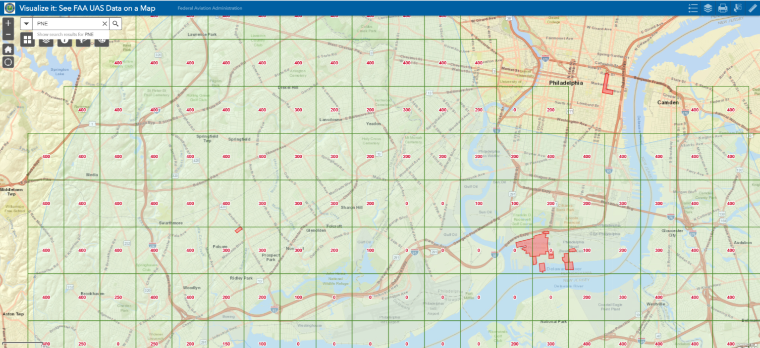
PHL; Philadelphia International Airport LAANC Map
That all changed in September 2018. The FAA now provides a system called Low Altitude Authorization and Notification Capability (LAANC), a collaboration between the FAA and industry. It directly supports UAS integration into the airspace around key larger airports.
The LAANC system now contains over five hundred US airports (view the airports on the FAA website here: https://goo.gl/7Ni9xR). Through an online portal, Part 107-certificated UAS pilots can now apply for a waiver in controlled airspace and receive permission almost instantaneously.
LAANC; How it Works
The FAA has determined that a certain part of controlled airspace will be out of the way of manned aircraft and safe for UAS pilots to fly to no more than four hundred feet above ground level (the FAA maximum allowed level for UAS operations except in the case of a structure).
The map shows a series of grid boxes within each controlled airspace that is one minute of longitude wide and one minute of latitude tall. That makes each box about one square mile (please see the illustration of the Philadelphia International Airport, PHL, LAANC map).
The red number in the middle of the box is the maximum altitude, in feet, above ground that the FAA will approve for UAS operation. As you might expect, approaches to runways have a 0-foot maximum or no-fly zone for a UAS. As you move farther away from where manned aircraft would be approaching runways, you will find grids with 50, 100, 150, 200, 300, and 400 feet above the ground markings. The entire grid system is superimposed over a choice of maps, such as one that denotes street names. You can locate the exact area where you will be flying, create an application online, and receive almost instantaneous airspace authorization.
We hope all business owners are prudent enough to hire only certificated UAS pilots with an aviation liability policy. Make sure you and your UAS vendor are aware of this brand-new technology that makes the waiver application process for flying in FAA-controlled airspace seamless.
Cerami Creative is a full-service digital and traditional marketing company founded in Philadelphia, Pennsylvania, in 1995. Cerami Creative has worked with national, regional, and local companies like Yuengling Beer, Penn Medicine, and Rita’s Water Ice. For a free evaluation of your company’s marketing strategy, contact Cerami Creative at info@CeramiCreative.com or call 215-893-3004. For a link to their UAS (drone) services website, go to www.WingsVideosUSA.com.